Make a donation
Gear up for your next adventure:
As an Amazon Associate, this site earns from qualifying purchases at no extra cost to you.
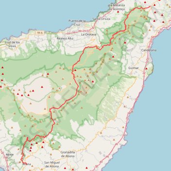
LONG TRAIL GR - 131 TENERIFE (CANARY ISLANDS) GR131 GR 131|trackspotting.com
- Distance: 87.7 Km
- Elevation gain: 4,437 m
- Maximum elevation: 2,404 m
- Elevation loss: 4,730 m
- Minimum elevation: 613 m
Interactive trail map
Make a donation
Gear up for your next adventure:
As an Amazon Associate, this site earns from qualifying purchases at no extra cost to you.
Trail profile
- Distance: 87.7 Km
- Elevation gain: 4,437 m
- Maximum elevation: 2,404 m
- Elevation loss: 4,730 m
- Minimum elevation: 613 m
Make a donation
Gear up for your next adventure:
As an Amazon Associate, this site earns from qualifying purchases at no extra cost to you.
About this trail
Name: LONG TRAIL GR - 131 TENERIFE (CANARY ISLANDS) GR131 GR 131|trackspotting.com trail, distance, elevation, map, profile, GPS track
Start: La Esperanza, El Rosario, Santa Cruz de Tenerife, Canary Islands, 38290, Spain (28.45150 -16.36740)
Coordinates: 28.09820 -16.69650 28.45160 -16.36740
Make a donation
Gear up for your next adventure:
As an Amazon Associate, this site earns from qualifying purchases at no extra cost to you.
Other hiking, mountain biking, running and outdoor activity trails
Click on a trail to view its statistics, map and profile.
Roques de Garcia - El Teide
Distance: 5.5 Km • Elevation gain: 254 m • Maximum elevation: 2,175 m