Import a GPX file

Santa Clarita Central Park loop walk

  • Distance: 1.6 Km
  • Elevation gain: 15 m
  • Maximum elevation: 387 m
  • Elevation loss: 15 m
  • Minimum elevation: 376 m
  • Moving time: 25 m 57 s
  • Moving speed: 3.7 Km/h
  • Maximum speed: 7.2 Km/h
  • Total time: 33 m 14 s
  • Global speed: 2.9 Km/h

Interactive trail map

Trail profile

  • Distance: 1.6 Km
  • Elevation gain: 15 m
  • Maximum elevation: 387 m
  • Elevation loss: 15 m
  • Minimum elevation: 376 m
  • Moving time: 25 m 57 s
  • Moving speed: 3.7 Km/h
  • Maximum speed: 7.2 Km/h
  • Total time: 33 m 14 s
  • Global speed: 2.9 Km/h

About this trail
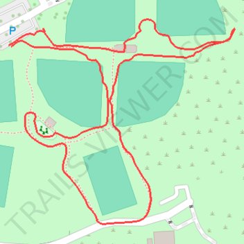
Name: Santa Clarita Central Park loop walk trail, distance, elevation, map, profile, GPS track

Start: Bouquet Canyon Road, Santa Clarita, Los Angeles County, California, 91350, United States (34.43450 -118.52160)

End: Bouquet Canyon Road, Santa Clarita, Los Angeles County, California, 91350, United States (34.43448 -118.52156)

Coordinates: 34.43207 -118.52160 34.43485 -118.51789

Gear up for your next adventure:

🎒Hiking Daypack - Lightweight and durable backpacks for day trips and excursions
👖Convertible Hiking Pants - Zip-off legs to adapt to changing weather conditions
🧤Insulated Winter Gloves - Heavy-duty protection for sub-zero Canadian adventures
🦶Anti-Blister Balm - Prevents friction and hotspots during long ascents
👟Trail Running Shoes - Agile footwear for fast-paced topographic exploration

As an Amazon Associate, this site earns from qualifying purchases at no extra cost to you.