Copia di Giretto di controllo sul pastello
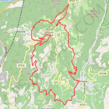
- Distance: 24.4 Km
- Elevation gain: 903 m
- Maximum elevation: 755 m
- Elevation loss: 902 m
- Minimum elevation: 173 m
Interactive trail map
Trail profile
- Distance: 24.4 Km
- Elevation gain: 903 m
- Maximum elevation: 755 m
- Elevation loss: 902 m
- Minimum elevation: 173 m
About this trail
Name: Copia di Giretto di controllo sul pastello trail, distance, elevation, map, profile, GPS track
Start: Via Roma, Fumane, Verona, Veneto, 37022, Italy (45.54292 10.88203)
End: Via Roma, Fumane, Verona, Veneto, 37022, Italy (45.54276 10.88167)
Coordinates: 45.53148 10.84790 45.58021 10.88209