Thank you for supporting this site ❤️
Make a donation
Make a donation
Gear up for your next adventure:
As an Amazon Associate, this site earns from qualifying purchases at no extra cost to you.
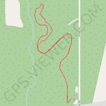
Kamview Nordic Ski Centre
- Distance: 3.4 Km
- Elevation gain: 27 m
- Maximum elevation: 242 m
- Elevation loss: 27 m
- Minimum elevation: 218 m
Interactive trail map
Thank you for supporting this site ❤️
Make a donation
Make a donation
Gear up for your next adventure:
As an Amazon Associate, this site earns from qualifying purchases at no extra cost to you.
Trail profile
- Distance: 3.4 Km
- Elevation gain: 27 m
- Maximum elevation: 242 m
- Elevation loss: 27 m
- Minimum elevation: 218 m
Thank you for supporting this site ❤️
Make a donation
Make a donation
Gear up for your next adventure:
As an Amazon Associate, this site earns from qualifying purchases at no extra cost to you.
About this trail
Name: Kamview Nordic Ski Centre trail, distance, elevation, map, profile, GPS track
Coordinates: 48.32634 -89.36671 48.33456 -89.36199
Topography: Thunder Bay topographic map, elevation, terrain
Thank you for supporting this site ❤️
Make a donation
Make a donation
Gear up for your next adventure:
As an Amazon Associate, this site earns from qualifying purchases at no extra cost to you.
Other hiking, mountain biking, running and outdoor activity trails
Click on a trail to view its statistics, map and profile.
Kamview Nordic Ski Centre
Canada > Ontario > Thunder Bay District > Thunder Bay
Distance: 3.4 Km • Elevation gain: 27 m • Maximum elevation: 242 m