Hemlock Ravine Park Loop
Hemlock Ravine Park. Bedford Basin. #Hiking #Running #Snowshoeing #Hemlock
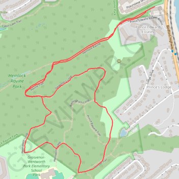
- Distance: 4.1 Km
- Elevation gain: 75 m
- Maximum elevation: 71 m
- Elevation loss: 75 m
- Minimum elevation: 16 m
Interactive trail map
Trail profile
- Distance: 4.1 Km
- Elevation gain: 75 m
- Maximum elevation: 71 m
- Elevation loss: 75 m
- Minimum elevation: 16 m
About this trail
Name: Hemlock Ravine Park Loop trail, distance, elevation, map, profile, GPS track
Coordinates: 44.68647 -63.67092 44.69476 -63.66174
Topography: Halifax topographic map, elevation, terrain
Other hiking, mountain biking, running and outdoor activity trails
Click on a trail to view its statistics, map and profile.
Halifax - Upper Sackville
Canada > Nova Scotia > Halifax County > Halifax
#Bike #Halifax #UpperSackville
Distance: 35.3 Km • Elevation gain: 396 m • Maximum elevation: 138 m
Brookfield - Halifax
Canada > Nova Scotia > Municipality of Colchester > Brookfield
Distance: 92.2 Km • Elevation gain: 658 m • Maximum elevation: 66 m