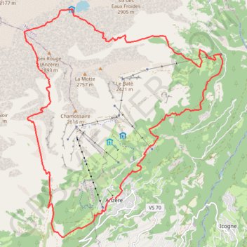
ANZERE_TRAIL DES AUDANNES
- Distance: 25.1 Km
- Elevation gain: 1,567 m
- Maximum elevation: 2,725 m
- Elevation loss: 1,578 m
- Minimum elevation: 1,478 m
Interactive trail map
Trail profile
- Distance: 25.1 Km
- Elevation gain: 1,567 m
- Maximum elevation: 2,725 m
- Elevation loss: 1,578 m
- Minimum elevation: 1,478 m
About this trail
Name: ANZERE_TRAIL DES AUDANNES trail, distance, elevation, map, profile, GPS track
Start: Route Nord, Les Bochonès, Anzère, Ayent, Hérens, Wallis, 1972, Switzerland (46.29772 7.39861)
Coordinates: 46.28784 7.36749 46.34346 7.43730
Other hiking, mountain biking, running and outdoor activity trails
Click on a trail to view its statistics, map and profile.
PT23DS2 Lörrach → Cadaqués
Germany > Baden-Württemberg > Landkreis Lörrach > Lörrach (Kernstadt)
Distance: 1,050.7 Km • Elevation gain: 13,130 m • Maximum elevation: 1,505 m