Thank you for supporting this site ❤️
Make a donation
Make a donation
Gear up for your next adventure:
As an Amazon Associate, this site earns from qualifying purchases at no extra cost to you.
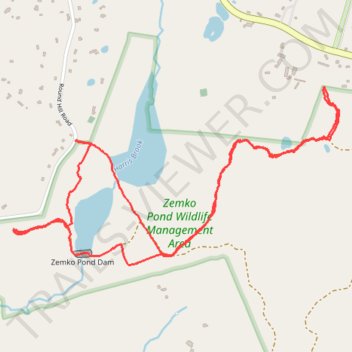
Hiking trail in Zemko Pond Wildlife Management Area
- Distance: 5.5 Km
- Elevation gain: 80 m
- Maximum elevation: 176 m
- Elevation loss: 80 m
- Minimum elevation: 134 m
- Moving time: 1 h 29 m
- Moving speed: 3.7 Km/h
- Maximum speed: 5.3 Km/h
- Total time: 1 h 55 m
- Global speed: 2.9 Km/h
Interactive trail map
Thank you for supporting this site ❤️
Make a donation
Make a donation
Gear up for your next adventure:
As an Amazon Associate, this site earns from qualifying purchases at no extra cost to you.
Trail profile
- Distance: 5.5 Km
- Elevation gain: 80 m
- Maximum elevation: 176 m
- Elevation loss: 80 m
- Minimum elevation: 134 m
- Moving time: 1 h 29 m
- Moving speed: 3.7 Km/h
- Maximum speed: 5.3 Km/h
- Total time: 1 h 55 m
- Global speed: 2.9 Km/h
Thank you for supporting this site ❤️
Make a donation
Make a donation
Gear up for your next adventure:
As an Amazon Associate, this site earns from qualifying purchases at no extra cost to you.
About this trail
Name: Hiking trail in Zemko Pond Wildlife Management Area trail, distance, elevation, map, profile, GPS track
Coordinates: 41.49612 -72.25877 41.50371 -72.24022
Thank you for supporting this site ❤️
Make a donation
Make a donation
Gear up for your next adventure:
As an Amazon Associate, this site earns from qualifying purchases at no extra cost to you.