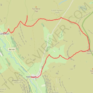
Great Whernside
- Distance: 13.3 Km
- Elevation gain: 565 m
- Maximum elevation: 704 m
- Elevation loss: 586 m
- Minimum elevation: 209 m
- Moving time: 3 h 36 m
- Moving speed: 3.7 Km/h
- Maximum speed: 6.5 Km/h
- Total time: 3 h 57 m
- Global speed: 3.4 Km/h
Interactive trail map
Trail profile
- Distance: 13.3 Km
- Elevation gain: 565 m
- Maximum elevation: 704 m
- Elevation loss: 586 m
- Minimum elevation: 209 m
- Moving time: 3 h 36 m
- Moving speed: 3.7 Km/h
- Maximum speed: 6.5 Km/h
- Total time: 3 h 57 m
- Global speed: 3.4 Km/h
About this trail
Name: Great Whernside trail, distance, elevation, map, profile, GPS track
Coordinates: 54.14623 -2.07363 54.17831 -1.99786
Other hiking, mountain biking, running and outdoor activity trails
Click on a trail to view its statistics, map and profile.
Dales Way
United Kingdom > England > North Yorkshire > Starbotton
Distance: 13.7 Km • Elevation gain: 234 m • Maximum elevation: 336 m
Hike from Grassington to Kettlewell
United Kingdom > England > North Yorkshire > Skipton
Distance: 15.4 Km • Elevation gain: 438 m • Maximum elevation: 516 m