Make a donation
Gear up for your next adventure:
As an Amazon Associate, this site earns from qualifying purchases at no extra cost to you.
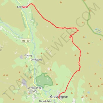
Hike from Grassington to Kettlewell
- Distance: 15.4 Km
- Elevation gain: 438 m
- Maximum elevation: 516 m
- Elevation loss: 425 m
- Minimum elevation: 196 m
- Moving time: 3 h 56 m
- Moving speed: 3.9 Km/h
- Maximum speed: 6.3 Km/h
- Total time: 4 h 41 m
- Global speed: 3.3 Km/h
Interactive trail map
Make a donation
Gear up for your next adventure:
As an Amazon Associate, this site earns from qualifying purchases at no extra cost to you.
Trail profile
- Distance: 15.4 Km
- Elevation gain: 438 m
- Maximum elevation: 516 m
- Elevation loss: 425 m
- Minimum elevation: 196 m
- Moving time: 3 h 56 m
- Moving speed: 3.9 Km/h
- Maximum speed: 6.3 Km/h
- Total time: 4 h 41 m
- Global speed: 3.3 Km/h
Make a donation
Gear up for your next adventure:
As an Amazon Associate, this site earns from qualifying purchases at no extra cost to you.
About this trail
Name: Hike from Grassington to Kettlewell trail, distance, elevation, map, profile, GPS track
Coordinates: 54.07006 -2.04955 54.14915 -1.96690
Make a donation
Gear up for your next adventure:
As an Amazon Associate, this site earns from qualifying purchases at no extra cost to you.
Other hiking, mountain biking, running and outdoor activity trails
Click on a trail to view its statistics, map and profile.
Dales Way
United Kingdom > England > North Yorkshire > Starbotton
Distance: 13.7 Km • Elevation gain: 234 m • Maximum elevation: 336 m
Hebden to Grassington loop via River Wharfe, back by Moors
United Kingdom > England > North Yorkshire > Hebden > Hole Bottom
Distance: 12.7 Km • Elevation gain: 237 m • Maximum elevation: 346 m
Great Whernside
United Kingdom > England > North Yorkshire > Starbotton
Distance: 13.3 Km • Elevation gain: 565 m • Maximum elevation: 704 m
Make a donation
Gear up for your next adventure:
As an Amazon Associate, this site earns from qualifying purchases at no extra cost to you.