Thank you for supporting this site ❤️
Make a donation
Make a donation
Gear up for your next adventure:
As an Amazon Associate, this site earns from qualifying purchases at no extra cost to you.
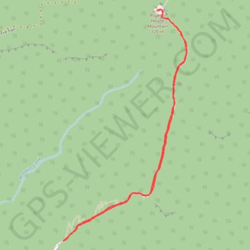
Pigeon House Mountain
Morton National Park. #Hiking #PigeonHouse #Morton
- Distance: 5.5 Km
- Elevation gain: 426 m
- Maximum elevation: 646 m
- Elevation loss: 426 m
- Minimum elevation: 226 m
Interactive trail map
Thank you for supporting this site ❤️
Make a donation
Make a donation
Gear up for your next adventure:
As an Amazon Associate, this site earns from qualifying purchases at no extra cost to you.
Trail profile
- Distance: 5.5 Km
- Elevation gain: 426 m
- Maximum elevation: 646 m
- Elevation loss: 426 m
- Minimum elevation: 226 m
Thank you for supporting this site ❤️
Make a donation
Make a donation
Gear up for your next adventure:
As an Amazon Associate, this site earns from qualifying purchases at no extra cost to you.
About this trail
Name: Pigeon House Mountain trail, distance, elevation, map, profile, GPS track
Coordinates: -35.36690 150.25616 -35.34926 150.26771
Thank you for supporting this site ❤️
Make a donation
Make a donation
Gear up for your next adventure:
As an Amazon Associate, this site earns from qualifying purchases at no extra cost to you.
Other hiking, mountain biking, running and outdoor activity trails
Click on a trail to view its statistics, map and profile.
Pigeon House Mountain Didthul
Distance: 5.7 Km • Elevation gain: 423 m • Maximum elevation: 645 m