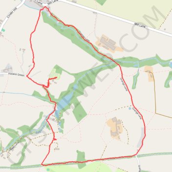
Cedar Lodge - Whitegate Way - Grange Lane
UK, Whitegate, Nortwhich
- Distance: 5.2 Km
- Elevation gain: 64 m
- Maximum elevation: 59 m
- Elevation loss: 64 m
- Minimum elevation: 31 m
- Moving time: 1 h 23 m
- Moving speed: 3.7 Km/h
- Maximum speed: 9.3 Km/h
- Total time: 1 h 49 m
- Global speed: 2.8 Km/h
Interactive trail map
Trail profile
- Distance: 5.2 Km
- Elevation gain: 64 m
- Maximum elevation: 59 m
- Elevation loss: 64 m
- Minimum elevation: 31 m
- Moving time: 1 h 23 m
- Moving speed: 3.7 Km/h
- Maximum speed: 9.3 Km/h
- Total time: 1 h 49 m
- Global speed: 2.8 Km/h
About this trail
Name: Cedar Lodge - Whitegate Way - Grange Lane trail, distance, elevation, map, profile, GPS track
Coordinates: 53.20443 -2.55749 53.21789 -2.54076
Other hiking, mountain biking, running and outdoor activity trails
Click on a trail to view its statistics, map and profile.
Cedar Lodge - the Plough Inn - Sixes Pool
United Kingdom > England > Cheshire West and Chester > Whitegate > Cassia Green
Footpaths Whitegate - Foxwist Green UK, whitegate, Nortwhich
Distance: 3.0 Km • Elevation gain: 38 m • Maximum elevation: 67 m
Footpaths Foxwist Green Cedar Lodge
United Kingdom > England > Cheshire West and Chester > Whitegate > Cassia Green
UK, Nortwhich
Distance: 3.4 Km • Elevation gain: 57 m • Maximum elevation: 63 m