Footpath next to Walter Bean Trail
- Distance: 11.0 Km
- Elevation gain: 96 m
- Maximum elevation: 323 m
- Elevation loss: 96 m
- Minimum elevation: 287 m
- Moving time: 1 h 23 m
- Moving speed: 7.9 Km/h
- Maximum speed: 11.1 Km/h
- Total time: 1 h 26 m
- Global speed: 7.6 Km/h
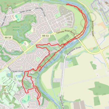
Interactive trail map
Trail profile
- Distance: 11.0 Km
- Elevation gain: 96 m
- Maximum elevation: 323 m
- Elevation loss: 96 m
- Minimum elevation: 287 m
- Moving time: 1 h 23 m
- Moving speed: 7.9 Km/h
- Maximum speed: 11.1 Km/h
- Total time: 1 h 26 m
- Global speed: 7.6 Km/h
About this trail
Name: Footpath next to Walter Bean Trail trail, distance, elevation, map, profile, GPS track
Coordinates: 43.42943 -80.41576 43.45556 -80.39255
Topography: Kitchener topographic map, elevation, terrain
Other hiking, mountain biking, running and outdoor activity trails
Click on a trail to view its statistics, map and profile.
Aldershot - Kitchener
Canada > Ontario > Halton Region > Burlington
#Bike
Distance: 79.0 Km • Elevation gain: 570 m • Maximum elevation: 346 m
Grand Valley Trail
Canada > Ontario > Region of Waterloo > Kitchener
Distance: 13.4 Km • Elevation gain: 136 m • Maximum elevation: 323 m