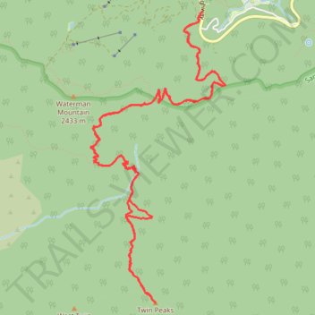
Twin Peaks Trail
- Distance: 16.1 Km
- Elevation gain: 1,093 m
- Maximum elevation: 2,360 m
- Elevation loss: 1,093 m
- Minimum elevation: 1,995 m
- Moving time: 5 h 27 m
- Moving speed: 2.9 Km/h
- Maximum speed: 5.4 Km/h
- Total time: 8 h 31 m
- Global speed: 1.9 Km/h
Interactive trail map
Trail profile
- Distance: 16.1 Km
- Elevation gain: 1,093 m
- Maximum elevation: 2,360 m
- Elevation loss: 1,093 m
- Minimum elevation: 1,995 m
- Moving time: 5 h 27 m
- Moving speed: 2.9 Km/h
- Maximum speed: 5.4 Km/h
- Total time: 8 h 31 m
- Global speed: 1.9 Km/h
About this trail
Name: Twin Peaks Trail trail, distance, elevation, map, profile, GPS track
Coordinates: 34.31574 -117.93465 34.34501 -117.91815
Other hiking, mountain biking, running and outdoor activity trails
Click on a trail to view its statistics, map and profile.