Make a donation
Gear up for your next adventure:
As an Amazon Associate, this site earns from qualifying purchases at no extra cost to you.
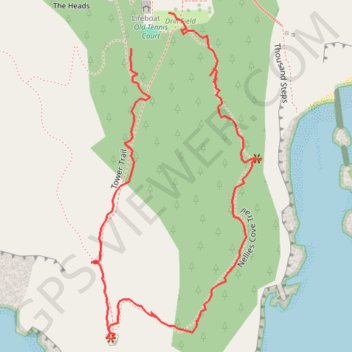
Port Orford Heads State Park Loop
Loop hike via Tower Trail and Nellies Cove Trail in the Port Orford Heads State Park. #Hiking #Loop #Nature #Sea #Pacific #Ocean #Forest
- Distance: 1.2 Km
- Elevation gain: 78 m
- Maximum elevation: 99 m
- Elevation loss: 78 m
- Minimum elevation: 43 m
- Moving time: 20 m 32 s
- Moving speed: 3.5 Km/h
- Maximum speed: 16.0 Km/h
- Total time: 30 m 29 s
- Global speed: 2.4 Km/h
Interactive trail map
Make a donation
Gear up for your next adventure:
As an Amazon Associate, this site earns from qualifying purchases at no extra cost to you.
Trail profile
- Distance: 1.2 Km
- Elevation gain: 78 m
- Maximum elevation: 99 m
- Elevation loss: 78 m
- Minimum elevation: 43 m
- Moving time: 20 m 32 s
- Moving speed: 3.5 Km/h
- Maximum speed: 16.0 Km/h
- Total time: 30 m 29 s
- Global speed: 2.4 Km/h
Make a donation
Gear up for your next adventure:
As an Amazon Associate, this site earns from qualifying purchases at no extra cost to you.
About this trail
Name: Port Orford Heads State Park Loop trail, distance, elevation, map, profile, GPS track
Start: Old Tennis Court, Tower Trail, Curry County, Oregon, 97465, United States (42.73866 -124.51058)
End: Drill Field, Tower Trail, Curry County, Oregon, 97465, United States (42.73904 -124.51004)
Coordinates: 42.73556 -124.51116 42.73904 -124.50870
Make a donation
Gear up for your next adventure:
As an Amazon Associate, this site earns from qualifying purchases at no extra cost to you.