Thank you for supporting this site ❤️
Make a donation
Make a donation
Gear up for your next adventure:
As an Amazon Associate, this site earns from qualifying purchases at no extra cost to you.
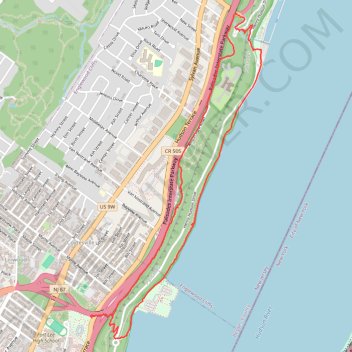
Palisades Shore Trail and Long Trail loop
- Distance: 6.3 Km
- Elevation gain: 209 m
- Maximum elevation: 109 m
- Elevation loss: 214 m
- Minimum elevation: 1 m
- Moving time: 1 h 15 m
- Moving speed: 5.0 Km/h
- Maximum speed: 16.2 Km/h
- Total time: 1 h 25 m
- Global speed: 4.5 Km/h
Interactive trail map
Thank you for supporting this site ❤️
Make a donation
Make a donation
Gear up for your next adventure:
As an Amazon Associate, this site earns from qualifying purchases at no extra cost to you.
Trail profile
- Distance: 6.3 Km
- Elevation gain: 209 m
- Maximum elevation: 109 m
- Elevation loss: 214 m
- Minimum elevation: 1 m
- Moving time: 1 h 15 m
- Moving speed: 5.0 Km/h
- Maximum speed: 16.2 Km/h
- Total time: 1 h 25 m
- Global speed: 4.5 Km/h
Thank you for supporting this site ❤️
Make a donation
Make a donation
Gear up for your next adventure:
As an Amazon Associate, this site earns from qualifying purchases at no extra cost to you.
About this trail
Name: Palisades Shore Trail and Long Trail loop trail, distance, elevation, map, profile, GPS track
End: Long Path, Fort Lee, Bergen County, New Jersey, 07024, United States (40.85958 -73.95936)
Coordinates: 40.85801 -73.96118 40.87908 -73.94659
Thank you for supporting this site ❤️
Make a donation
Make a donation
Gear up for your next adventure:
As an Amazon Associate, this site earns from qualifying purchases at no extra cost to you.
Other hiking, mountain biking, running and outdoor activity trails
Click on a trail to view its statistics, map and profile.