Import a GPX file

Fort Lee trails

Click on a trail to view its statistics, map and profile.
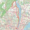
GFNY World Championship NYC 2026

United States > New Jersey > Bergen County > Fort Lee

Distance: 136.6 Km • Elevation gain: 2,449 m • Maximum elevation: 263 m

Palisades Shore Trail and Long Trail loop

United States > New Jersey > Bergen County > Fort Lee > Coytesville

Distance: 6.3 Km • Elevation gain: 209 m • Maximum elevation: 109 m

Other places

Gear up for your next adventure:

🛰️Satellite Messenger - Emergency communication for areas with no cell service
🔋Solar Power Bank - Keep your GPS and devices charged during long outdoor trips
🧳Compression Sacks - Maximize space in your backpack by shrinking gear
🎒Backpack Rain Cover - External shield to keep your entire pack dry
🧴Insect Repellent - Protect yourself from bugs during outdoor adventures

As an Amazon Associate, this site earns from qualifying purchases at no extra cost to you.