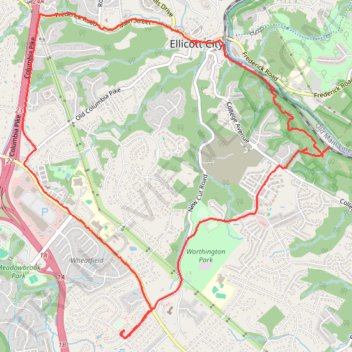
Patapsco Valley State Park - Ellicott City
- Distance: 12.6 Km
- Elevation gain: 256 m
- Maximum elevation: 148 m
- Elevation loss: 256 m
- Minimum elevation: 43 m
- Moving time: 1 h 48 m
- Moving speed: 7.0 Km/h
- Maximum speed: 20.1 Km/h
- Total time: 2 h 7 m
- Global speed: 5.9 Km/h
Interactive trail map
Trail profile
- Distance: 12.6 Km
- Elevation gain: 256 m
- Maximum elevation: 148 m
- Elevation loss: 256 m
- Minimum elevation: 43 m
- Moving time: 1 h 48 m
- Moving speed: 7.0 Km/h
- Maximum speed: 20.1 Km/h
- Total time: 2 h 7 m
- Global speed: 5.9 Km/h
About this trail
Name: Patapsco Valley State Park - Ellicott City trail, distance, elevation, map, profile, GPS track
Coordinates: 39.23915 -76.81971 39.27021 -76.78197
Other hiking, mountain biking, running and outdoor activity trails
Click on a trail to view its statistics, map and profile.
Old Ellicott City / OEC Connector Trail
United States > Maryland > Howard County > Ellicott City
Distance: 6.7 Km • Elevation gain: 149 m • Maximum elevation: 118 m
Patapsco Valley State Park Ilchester Area Loop
United States > Maryland > Howard County > Ilchester
Distance: 9.0 Km • Elevation gain: 315 m • Maximum elevation: 109 m
Hike through Patapsco Valley State Park Ilchester Area
United States > Maryland > Howard County > Ilchester
Distance: 8.5 Km • Elevation gain: 279 m • Maximum elevation: 108 m
St. Marys's College Ruins and Patapsco Valley State Park Illchester Area hike
United States > Maryland > Howard County > Ilchester
Distance: 4.8 Km • Elevation gain: 152 m • Maximum elevation: 104 m
Ellicott City - Meadowbrook Park
United States > Maryland > Howard County > Ellicott City
Distance: 12.1 Km • Elevation gain: 103 m • Maximum elevation: 160 m
Crossing Patapsco Valley State Park Ilchester Area
United States > Maryland > Howard County > Ilchester
Morning Hike
Distance: 5.8 Km • Elevation gain: 225 m • Maximum elevation: 110 m
Ellicott City - Meadowbrook Park Loop
United States > Maryland > Howard County > Ellicott City
Distance: 6.4 Km • Elevation gain: 61 m • Maximum elevation: 133 m
Patapsco Valley State Park - Horse Farm Area
United States > Maryland > Howard County > Ellicott City
Distance: 13.0 Km • Elevation gain: 240 m • Maximum elevation: 113 m
Patapsco Valley State Park Ilchester Area
United States > Maryland > Howard County > Ilchester
Morning Hike
Distance: 7.7 Km • Elevation gain: 261 m • Maximum elevation: 109 m
Patapsco Valley State Park Ilchester Area
United States > Maryland > Howard County > Ilchester
Morning Hike
Distance: 7.2 Km • Elevation gain: 215 m • Maximum elevation: 108 m
Old Ilchester Quarry Scouting
United States > Maryland > Howard County > Ilchester
Patapsco Valley State Park - Morning Hike
Distance: 8.3 Km • Elevation gain: 292 m • Maximum elevation: 108 m
Scouting Old Ilchester
United States > Maryland > Howard County > Ilchester
Morning Hike
Distance: 7.9 Km • Elevation gain: 255 m • Maximum elevation: 108 m
Scouting Old Ilchester
United States > Maryland > Howard County > Ilchester
Morning Hike
Distance: 7.9 Km • Elevation gain: 224 m • Maximum elevation: 108 m