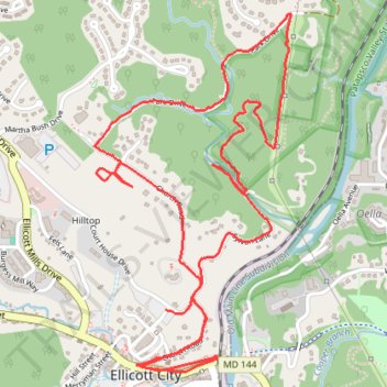
Old Ellicott City / OEC Connector Trail
- Distance: 6.7 Km
- Elevation gain: 149 m
- Maximum elevation: 118 m
- Elevation loss: 151 m
- Minimum elevation: 43 m
- Moving time: 1 h 37 m
- Moving speed: 4.1 Km/h
- Maximum speed: 12.0 Km/h
- Total time: 1 h 42 m
- Global speed: 3.9 Km/h
Interactive trail map
Trail profile
- Distance: 6.7 Km
- Elevation gain: 149 m
- Maximum elevation: 118 m
- Elevation loss: 151 m
- Minimum elevation: 43 m
- Moving time: 1 h 37 m
- Moving speed: 4.1 Km/h
- Maximum speed: 12.0 Km/h
- Total time: 1 h 42 m
- Global speed: 3.9 Km/h
About this trail
Name: Old Ellicott City / OEC Connector Trail trail, distance, elevation, map, profile, GPS track
Coordinates: 39.26741 -76.80064 39.28028 -76.79148
Other hiking, mountain biking, running and outdoor activity trails
Click on a trail to view its statistics, map and profile.
Patapsco Valley State Park - Horse Farm Area
United States > Maryland > Howard County > Ellicott City
Distance: 13.0 Km • Elevation gain: 240 m • Maximum elevation: 113 m
Patapsco Valley State Park - Ellicott City
United States > Maryland > Howard County > Ellicott City
Distance: 12.6 Km • Elevation gain: 256 m • Maximum elevation: 148 m