Thank you for supporting this site ❤️
Make a donation
Make a donation
Gear up for your next adventure:
As an Amazon Associate, this site earns from qualifying purchases at no extra cost to you.
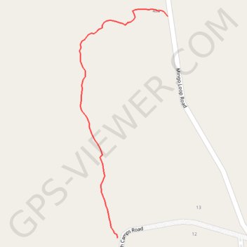
Forest path from North Camps Road to Mingo Loop Road in Rangeley, ME
Forest, path, rangeley, nature
- Distance: 0.6 Km
- Elevation gain: 26 m
- Maximum elevation: 520 m
- Elevation loss: 1 m
- Minimum elevation: 493 m
- Moving time: 8 m 36 s
- Moving speed: 4.3 Km/h
- Maximum speed: 8.5 Km/h
- Total time: 8 m 36 s
- Global speed: 4.3 Km/h
Interactive trail map
Thank you for supporting this site ❤️
Make a donation
Make a donation
Gear up for your next adventure:
As an Amazon Associate, this site earns from qualifying purchases at no extra cost to you.
Trail profile
- Distance: 0.6 Km
- Elevation gain: 26 m
- Maximum elevation: 520 m
- Elevation loss: 1 m
- Minimum elevation: 493 m
- Moving time: 8 m 36 s
- Moving speed: 4.3 Km/h
- Maximum speed: 8.5 Km/h
- Total time: 8 m 36 s
- Global speed: 4.3 Km/h
Thank you for supporting this site ❤️
Make a donation
Make a donation
Gear up for your next adventure:
As an Amazon Associate, this site earns from qualifying purchases at no extra cost to you.
About this trail
Name: Forest path from North Camps Road to Mingo Loop Road in Rangeley, ME trail, distance, elevation, map, profile, GPS track
Start: 41, North Camps Road, Rangeley, Franklin County, Maine, 04970, United States (44.95920 -70.72663)
Coordinates: 44.95920 -70.72755 44.96310 -70.72542
Thank you for supporting this site ❤️
Make a donation
Make a donation
Gear up for your next adventure:
As an Amazon Associate, this site earns from qualifying purchases at no extra cost to you.