Import a GPX file

Footpaths and bridleways - St Catherines Down, Isle of Wight

  • Distance: 5.5 Km
  • Elevation gain: 184 m
  • Maximum elevation: 234 m
  • Elevation loss: 185 m
  • Minimum elevation: 103 m
  • Moving time: 1 h 8 m
  • Moving speed: 4.9 Km/h
  • Maximum speed: 8.4 Km/h
  • Total time: 1 h 16 m
  • Global speed: 4.3 Km/h

Interactive trail map

Trail profile

  • Distance: 5.5 Km
  • Elevation gain: 184 m
  • Maximum elevation: 234 m
  • Elevation loss: 185 m
  • Minimum elevation: 103 m
  • Moving time: 1 h 8 m
  • Moving speed: 4.9 Km/h
  • Maximum speed: 8.4 Km/h
  • Total time: 1 h 16 m
  • Global speed: 4.3 Km/h

About this trail
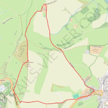
Name: Footpaths and bridleways - St Catherines Down, Isle of Wight trail, distance, elevation, map, profile, GPS track

Start: Blackgang Road, Blackgang, Chale, Isle of Wight, England, PO38 2JB, United Kingdom (50.58827 -1.30732)

End: Blackgang Road, Blackgang, Chale, Isle of Wight, England, PO38 2JB, United Kingdom (50.58829 -1.30738)

Coordinates: 50.58625 -1.30739 50.60250 -1.28667

Gear up for your next adventure:

🧤Rechargeable Heated Gloves - Extreme warmth for Canadian winter expeditions
🥾Trail Running Shoes - Lightweight and durable shoes for trail running
🥽Outdoor Goggles - Protective eyewear for outdoor activities
🥾All-Terrain Hiking Boots - Versatile boots for varied hiking conditions
🥾Mountaineering Boots - Supportive boots for climbing and high-altitude hiking

As an Amazon Associate, this site earns from qualifying purchases at no extra cost to you.