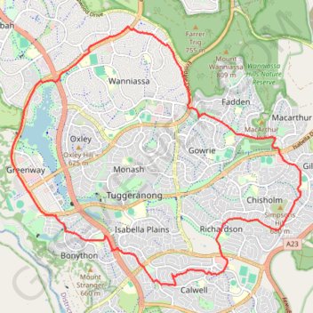
Import a GPX file

Tuggeranong Loop

#Bike #Loop

  • Distance: 22.3 Km
  • Elevation gain: 246 m
  • Maximum elevation: 673 m
  • Elevation loss: 246 m
  • Minimum elevation: 566 m

Interactive trail map

Trail profile

  • Distance: 22.3 Km
  • Elevation gain: 246 m
  • Maximum elevation: 673 m
  • Elevation loss: 246 m
  • Minimum elevation: 566 m

About this trail

Other hiking, mountain biking, running and outdoor activity trails

Click on a trail to view its statistics, map and profile.

Cloudride24.FINAL

Australia > North Canberra

Distance: 1,028.8 Km • Elevation gain: 21,282 m • Maximum elevation: 1,754 m

Gear up for your next adventure:

🔋Emergency Crank Radio - Weather alerts and power without needing batteries
🥾Mountain Hiking Shoes - Shoes with superior grip for mountainous terrain
🧢Outdoor Visor - Breathable visor for sunny hikes
🧢Hiking Sun Hat - Wide-brimmed protection for exposed mountain ridges
🥾Hiking Boots - Sturdy boots providing ankle support and traction on rugged trails

As an Amazon Associate, this site earns from qualifying purchases at no extra cost to you.