Thank you for supporting this site ❤️
Make a donation
Make a donation
Gear up for your next adventure:
As an Amazon Associate, this site earns from qualifying purchases at no extra cost to you.
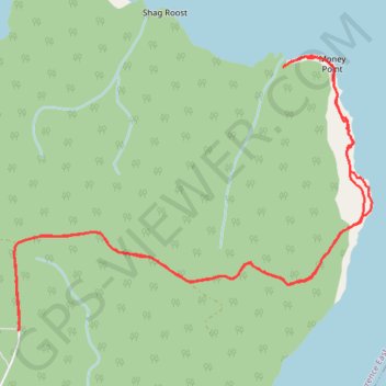
Cape Breton Island - Money Point
Gulf of Saint Lawrence. #Hiking #CapeBreton #SaintLawrence #Atlantic
- Distance: 11.3 Km
- Elevation gain: 556 m
- Maximum elevation: 378 m
- Elevation loss: 556 m
- Minimum elevation: 0 m
Interactive trail map
Thank you for supporting this site ❤️
Make a donation
Make a donation
Gear up for your next adventure:
As an Amazon Associate, this site earns from qualifying purchases at no extra cost to you.
Trail profile
- Distance: 11.3 Km
- Elevation gain: 556 m
- Maximum elevation: 378 m
- Elevation loss: 556 m
- Minimum elevation: 0 m
Thank you for supporting this site ❤️
Make a donation
Make a donation
Gear up for your next adventure:
As an Amazon Associate, this site earns from qualifying purchases at no extra cost to you.
About this trail
Name: Cape Breton Island - Money Point trail, distance, elevation, map, profile, GPS track
Coordinates: 47.01074 -60.42344 47.02971 -60.38728
Topography: Municipality of Victoria County topographic map, elevation, terrain
Thank you for supporting this site ❤️
Make a donation
Make a donation
Gear up for your next adventure:
As an Amazon Associate, this site earns from qualifying purchases at no extra cost to you.