
Bison Mountain Loop
Loop hike from Lost Park Campground to Bison Mountain via Brookside-McCurdy, McCurdy Park, Goose Creek and Wigwam in the Lost Creek Wilderness. #Hiking #Loop #Mountain #Nature #Forest #River #Wilderness
- Distance: 48.0 Km
- Elevation gain: 1,893 m
- Maximum elevation: 3,780 m
- Elevation loss: 1,917 m
- Minimum elevation: 2,705 m
- Moving time: 18 h 48 s
- Moving speed: 2.7 Km/h
- Maximum speed: 5.7 Km/h
- Total time: 2 d 1 h
- Global speed: 1.0 Km/h
Interactive trail map
Trail profile
- Distance: 48.0 Km
- Elevation gain: 1,893 m
- Maximum elevation: 3,780 m
- Elevation loss: 1,917 m
- Minimum elevation: 2,705 m
- Moving time: 18 h 48 s
- Moving speed: 2.7 Km/h
- Maximum speed: 5.7 Km/h
- Total time: 2 d 1 h
- Global speed: 1.0 Km/h
About this trail
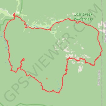
Name: Bison Mountain Loop trail, distance, elevation, map, profile, GPS track
Start: Brookside-McCurdy Trail, Park County, Colorado, United States (39.28419 -105.50888)
End: Wigwam Trail, Park County, Colorado, United States (39.28274 -105.50894)
Coordinates: 39.20464 -105.52332 39.28419 -105.39748