Mount Flora Trail in Arapaho National Forest
The Mount Flora Trail in Arapaho National Forest offers a challenging and rewarding hiking experience, especially for those seeking high-altitude adventures. Starting from Berthoud Pass, the trail ascends steeply through alpine tundra, with expansive panoramic views of the surrounding peaks, including Ethel Lake and nearby Breckinridge Peak. Hikers are also treated to glimpses of wildflowers in summer and may encounter marmots along the way, making it a uniquely vibrant and dynamic route. #Hiking #Mountain #Forest #Nature
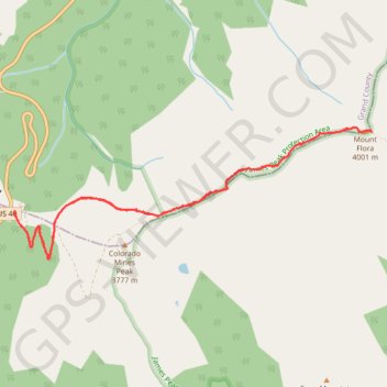
- Distance: 10.2 Km
- Elevation gain: 558 m
- Maximum elevation: 3,999 m
- Elevation loss: 558 m
- Minimum elevation: 3,452 m
- Moving time: 2 h 19 m
- Moving speed: 4.4 Km/h
- Maximum speed: 8.2 Km/h
- Total time: 3 h 2 m
- Global speed: 3.3 Km/h
Interactive trail map
Trail profile
- Distance: 10.2 Km
- Elevation gain: 558 m
- Maximum elevation: 3,999 m
- Elevation loss: 558 m
- Minimum elevation: 3,452 m
- Moving time: 2 h 19 m
- Moving speed: 4.4 Km/h
- Maximum speed: 8.2 Km/h
- Total time: 3 h 2 m
- Global speed: 3.3 Km/h
About this trail
Name: Mount Flora Trail in Arapaho National Forest trail, distance, elevation, map, profile, GPS track
Start: US 40, Grand County, Colorado, United States (39.79797 -105.77663)
End: US 40, Grand County, Colorado, United States (39.79783 -105.77664)
Coordinates: 39.79365 -105.77666 39.80529 -105.73557