Make a donation
Gear up for your next adventure:
As an Amazon Associate, this site earns from qualifying purchases at no extra cost to you.
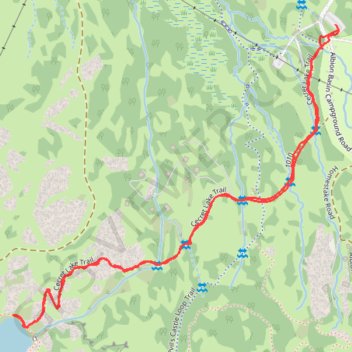
Cecret Lake Trail in Uinta-Wasatch-Cache National Forest
The Cecret Lake Trail in the Uinta-Wasatch-Cache National Forest offers a beautiful and easy hike, especially in the summer when the Albion Basin is teeming with wildflowers. The route passes through open meadows with stunning views of surrounding peaks like Mount Superior and Devil's Castle, and the lake itself is a peaceful, reflective spot beneath jagged cliffs. This short, well-maintained trail is ideal for families and photographers, providing an accessible way to experience the alpine beauty of the Wasatch Mountains. #Hiking #Mountain #Forest #Nature #Lake
- Distance: 2.8 Km
- Elevation gain: 136 m
- Maximum elevation: 3,010 m
- Elevation loss: 137 m
- Minimum elevation: 2,874 m
- Moving time: 59 m 44 s
- Moving speed: 2.8 Km/h
- Maximum speed: 4.9 Km/h
- Total time: 1 h 7 m
- Global speed: 2.5 Km/h
Interactive trail map
Make a donation
Gear up for your next adventure:
As an Amazon Associate, this site earns from qualifying purchases at no extra cost to you.
Trail profile
- Distance: 2.8 Km
- Elevation gain: 136 m
- Maximum elevation: 3,010 m
- Elevation loss: 137 m
- Minimum elevation: 2,874 m
- Moving time: 59 m 44 s
- Moving speed: 2.8 Km/h
- Maximum speed: 4.9 Km/h
- Total time: 1 h 7 m
- Global speed: 2.5 Km/h
Make a donation
Gear up for your next adventure:
As an Amazon Associate, this site earns from qualifying purchases at no extra cost to you.
About this trail
Name: Cecret Lake Trail in Uinta-Wasatch-Cache National Forest trail, distance, elevation, map, profile, GPS track
Coordinates: 40.57152 -111.62182 40.57787 -111.61283
Make a donation
Gear up for your next adventure:
As an Amazon Associate, this site earns from qualifying purchases at no extra cost to you.
Other hiking, mountain biking, running and outdoor activity trails
Click on a trail to view its statistics, map and profile.
Cecret Lake Trail via Upper Albion Meadows Trail in Uinta-Wasatch-Cache National Forest
United States > Utah > Salt Lake County > Alta
The hike to Cecret Lake via the Upper Albion Meadows Trail offers a peaceful journey through colorful wildflower meadows, leading to a serene alpine lake surrounded by striking rocky cliffs. As you ascend, you’ll be treated to views of Albion Basin, where vibrant summer wildflowers and the chance to spot…
Distance: 7.3 Km • Elevation gain: 364 m • Maximum elevation: 3,010 m
Twin Peaks
United States > Utah > Salt Lake County > Alta
Cecret Lake, Mount Baldy, Hidden Peak. Rocky Mountains. #Hiking #RockyMountains
Distance: 15.5 Km • Elevation gain: 1,103 m • Maximum elevation: 3,487 m