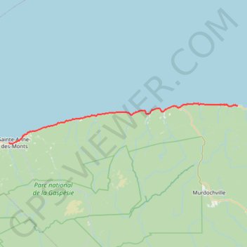
Sainte-Anne-des-Monts - Madeleine
Saint Lawrence River. #Bike #SainteAnneDesMonts #Madeleine #SaintLawrence
- Distance: 92.5 Km
- Elevation gain: 866 m
- Maximum elevation: 107 m
- Elevation loss: 847 m
- Minimum elevation: -2 m
Interactive trail map
Trail profile
- Distance: 92.5 Km
- Elevation gain: 866 m
- Maximum elevation: 107 m
- Elevation loss: 847 m
- Minimum elevation: -2 m
About this trail
Name: Sainte-Anne-des-Monts - Madeleine trail, distance, elevation, map, profile, GPS track
Coordinates: 49.12301 -66.51096 49.25643 -65.34904
Topography: La Haute-Gaspésie topographic map, elevation, terrain
Other hiking, mountain biking, running and outdoor activity trails
Click on a trail to view its statistics, map and profile.
Madeleine - Gaspé
Canada > Quebec > La Haute-Gaspésie > Sainte-Madeleine-de-la-Rivière-Madeleine > Madeleine-Centre
Gulf of Saint Lawrence. #Bike #Madeleine #Gaspé #SaintLawrence #Atlantic
Distance: 120.1 Km • Elevation gain: 2,303 m • Maximum elevation: 294 m
Matane - Sainte-Anne-des-Monts
Canada > Quebec > La Matanie > Matane
Saint Lawrence River. #Bike #Matane #SainteAnneDesMonts #SaintLawrence
Distance: 88.8 Km • Elevation gain: 788 m • Maximum elevation: 90 m