Make a donation
Gear up for your next adventure:
As an Amazon Associate, this site earns from qualifying purchases at no extra cost to you.
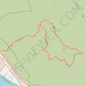
Mugu Peak Loop
Loop hike to Mugu Peak by the Chumash Trail and the Mugu Peak Trail in the La Jolla Valley Natural Preserve and the Point Mugu State Park. #Hiking #Loop #Mountain #Nature #Park #Sea #Pacific #Ocean
- Distance: 4.6 Km
- Elevation gain: 440 m
- Maximum elevation: 384 m
- Elevation loss: 440 m
- Minimum elevation: 10 m
Interactive trail map
Make a donation
Gear up for your next adventure:
As an Amazon Associate, this site earns from qualifying purchases at no extra cost to you.
Trail profile
- Distance: 4.6 Km
- Elevation gain: 440 m
- Maximum elevation: 384 m
- Elevation loss: 440 m
- Minimum elevation: 10 m
Make a donation
Gear up for your next adventure:
As an Amazon Associate, this site earns from qualifying purchases at no extra cost to you.
About this trail
Name: Mugu Peak Loop trail, distance, elevation, map, profile, GPS track
Start: Pacific Coast Highway, Ventura County, California, United States (34.09179 -119.06557)
End: Chumash Trail, Ventura County, California, United States (34.09176 -119.06556)
Coordinates: 34.08979 -119.06557 34.09628 -119.05180
Make a donation
Gear up for your next adventure:
As an Amazon Associate, this site earns from qualifying purchases at no extra cost to you.