Thank you for supporting this site ❤️
Make a donation
Make a donation
Gear up for your next adventure:
As an Amazon Associate, this site earns from qualifying purchases at no extra cost to you.
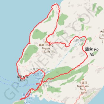
響巖 東樓坑 墨洲洞
Islands District Hike
- Distance: 6.7 Km
- Elevation gain: 234 m
- Maximum elevation: 177 m
- Elevation loss: 234 m
- Minimum elevation: 0 m
- Moving time: 2 h 42 m
- Moving speed: 2.5 Km/h
- Maximum speed: 9.9 Km/h
- Total time: 4 h 52 m
- Global speed: 1.4 Km/h
Interactive trail map
Thank you for supporting this site ❤️
Make a donation
Make a donation
Gear up for your next adventure:
As an Amazon Associate, this site earns from qualifying purchases at no extra cost to you.
Trail profile
- Distance: 6.7 Km
- Elevation gain: 234 m
- Maximum elevation: 177 m
- Elevation loss: 234 m
- Minimum elevation: 0 m
- Moving time: 2 h 42 m
- Moving speed: 2.5 Km/h
- Maximum speed: 9.9 Km/h
- Total time: 4 h 52 m
- Global speed: 1.4 Km/h
Thank you for supporting this site ❤️
Make a donation
Make a donation
Gear up for your next adventure:
As an Amazon Associate, this site earns from qualifying purchases at no extra cost to you.
About this trail
Name: 響巖 東樓坑 墨洲洞 trail, distance, elevation, map, profile, GPS track
Coordinates: 22.16108 114.24994 22.17500 114.26108
Thank you for supporting this site ❤️
Make a donation
Make a donation
Gear up for your next adventure:
As an Amazon Associate, this site earns from qualifying purchases at no extra cost to you.