Thank you for supporting this site ❤️
Make a donation
Make a donation
Gear up for your next adventure:
As an Amazon Associate, this site earns from qualifying purchases at no extra cost to you.
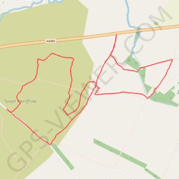
Tywyn Aberffraw
Isle of Anglesey Trail Running
- Distance: 6.1 Km
- Elevation gain: 28 m
- Maximum elevation: 24 m
- Elevation loss: 28 m
- Minimum elevation: 9 m
- Moving time: 55 m 43 s
- Moving speed: 6.5 Km/h
- Maximum speed: 10.8 Km/h
- Total time: 1 h 5 m
- Global speed: 5.6 Km/h
Interactive trail map
Thank you for supporting this site ❤️
Make a donation
Make a donation
Gear up for your next adventure:
As an Amazon Associate, this site earns from qualifying purchases at no extra cost to you.
Trail profile
- Distance: 6.1 Km
- Elevation gain: 28 m
- Maximum elevation: 24 m
- Elevation loss: 28 m
- Minimum elevation: 9 m
- Moving time: 55 m 43 s
- Moving speed: 6.5 Km/h
- Maximum speed: 10.8 Km/h
- Total time: 1 h 5 m
- Global speed: 5.6 Km/h
Thank you for supporting this site ❤️
Make a donation
Make a donation
Gear up for your next adventure:
As an Amazon Associate, this site earns from qualifying purchases at no extra cost to you.
About this trail
Name: Tywyn Aberffraw trail, distance, elevation, map, profile, GPS track
Start: A4080, Aberffraw, Isle of Anglesey, Wales, LL63 5AX, United Kingdom (53.19509 -4.43910)
End: A4080, Aberffraw, Isle of Anglesey, Wales, LL63 5AX, United Kingdom (53.19505 -4.43910)
Coordinates: 53.18554 -4.45501 53.19509 -4.43098
Thank you for supporting this site ❤️
Make a donation
Make a donation
Gear up for your next adventure:
As an Amazon Associate, this site earns from qualifying purchases at no extra cost to you.