The Grotto Waterfall via First Creek Trail in Red Rock Canyon National Conservation Area
First Creek Trail offers a peaceful trek through the open desert before gradually leading you toward more rugged, scenic terrain. As you approach the mouth of the canyon, the landscape shifts, and the hidden waterfall provides a refreshing reward for those who take the slight detour. It's an ideal hike for those seeking a manageable adventure with a touch of challenge and desert beauty. #Hiking #Desert #Waterfall #Nature
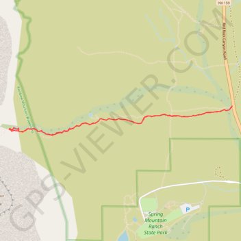
- Distance: 5.7 Km
- Elevation gain: 149 m
- Maximum elevation: 1,249 m
- Elevation loss: 149 m
- Minimum elevation: 1,111 m
- Moving time: 1 h 13 m
- Moving speed: 4.7 Km/h
- Maximum speed: 11.2 Km/h
- Total time: 1 h 22 m
- Global speed: 4.2 Km/h
Interactive trail map
Trail profile
- Distance: 5.7 Km
- Elevation gain: 149 m
- Maximum elevation: 1,249 m
- Elevation loss: 149 m
- Minimum elevation: 1,111 m
- Moving time: 1 h 13 m
- Moving speed: 4.7 Km/h
- Maximum speed: 11.2 Km/h
- Total time: 1 h 22 m
- Global speed: 4.2 Km/h
About this trail
Name: The Grotto Waterfall via First Creek Trail in Red Rock Canyon National Conservation Area trail, distance, elevation, map, profile, GPS track
End: First Creek, Clark County, Nevada, 89161, United States (36.08146 -115.44801)
Coordinates: 36.07847 -115.47596 36.08146 -115.44800