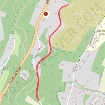
Thank you for supporting this site ❤️
Make a donation
Make a donation
Gear up for your next adventure:
As an Amazon Associate, this site earns from qualifying purchases at no extra cost to you.
Polecat Valley
- Distance: 2.5 Km
- Elevation gain: 47 m
- Maximum elevation: 199 m
- Elevation loss: 47 m
- Minimum elevation: 162 m
- Moving time: 14 m 43 s
- Moving speed: 10.3 Km/h
- Maximum speed: 14.1 Km/h
- Total time: 14 m 43 s
- Global speed: 10.3 Km/h
Interactive trail map
Thank you for supporting this site ❤️
Make a donation
Make a donation
Gear up for your next adventure:
As an Amazon Associate, this site earns from qualifying purchases at no extra cost to you.
Trail profile
- Distance: 2.5 Km
- Elevation gain: 47 m
- Maximum elevation: 199 m
- Elevation loss: 47 m
- Minimum elevation: 162 m
- Moving time: 14 m 43 s
- Moving speed: 10.3 Km/h
- Maximum speed: 14.1 Km/h
- Total time: 14 m 43 s
- Global speed: 10.3 Km/h
Thank you for supporting this site ❤️
Make a donation
Make a donation
Gear up for your next adventure:
As an Amazon Associate, this site earns from qualifying purchases at no extra cost to you.
About this trail
Name: Polecat Valley trail, distance, elevation, map, profile, GPS track
Coordinates: 51.09684 -0.73491 51.10644 -0.72976
Thank you for supporting this site ❤️
Make a donation
Make a donation
Gear up for your next adventure:
As an Amazon Associate, this site earns from qualifying purchases at no extra cost to you.