Thank you for supporting this site ❤️
Make a donation
Make a donation
Gear up for your next adventure:
As an Amazon Associate, this site earns from qualifying purchases at no extra cost to you.
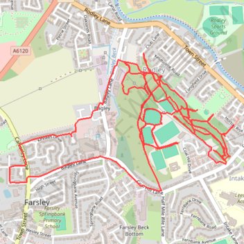
Trace of trails for Coal Hill, Rodley
- Distance: 9.9 Km
- Elevation gain: 212 m
- Maximum elevation: 110 m
- Elevation loss: 212 m
- Minimum elevation: 64 m
- Moving time: 1 h 31 m
- Moving speed: 6.5 Km/h
- Maximum speed: 13.8 Km/h
- Total time: 1 h 37 m
- Global speed: 6.1 Km/h
Interactive trail map
Thank you for supporting this site ❤️
Make a donation
Make a donation
Gear up for your next adventure:
As an Amazon Associate, this site earns from qualifying purchases at no extra cost to you.
Trail profile
- Distance: 9.9 Km
- Elevation gain: 212 m
- Maximum elevation: 110 m
- Elevation loss: 212 m
- Minimum elevation: 64 m
- Moving time: 1 h 31 m
- Moving speed: 6.5 Km/h
- Maximum speed: 13.8 Km/h
- Total time: 1 h 37 m
- Global speed: 6.1 Km/h
Thank you for supporting this site ❤️
Make a donation
Make a donation
Gear up for your next adventure:
As an Amazon Associate, this site earns from qualifying purchases at no extra cost to you.
About this trail
Name: Trace of trails for Coal Hill, Rodley trail, distance, elevation, map, profile, GPS track
Coordinates: 53.81490 -1.67205 53.82171 -1.65330
Thank you for supporting this site ❤️
Make a donation
Make a donation
Gear up for your next adventure:
As an Amazon Associate, this site earns from qualifying purchases at no extra cost to you.