Make a donation
Gear up for your next adventure:
As an Amazon Associate, this site earns from qualifying purchases at no extra cost to you.
Virginia Falls and St. Mary Falls in Glacier National Park
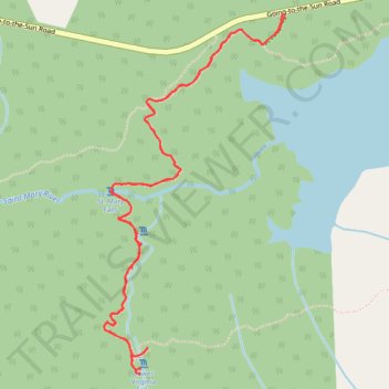
The St. Mary and Virginia Falls Trail in Glacier National Park offers a captivating journey through diverse landscapes. Starting near St. Mary Lake, hikers traverse areas affected by past wildfires, providing a unique contrast between new growth and charred remnants. Along the path, the trail meanders alongside the St. Mary River, leading to the impressive St. Mary Falls, where the water cascades over multi-tiered rock formations. Continuing upstream, hikers encounter Virginia Falls, a majestic waterfall plunging over mossy rocks into a lush forested setting. Throughout the hike, panoramic views of surrounding mountains, including Little Chief Mountain, Almost-A-Dog Mountain, and Dusty Star Mountain, enhance the experience. #Hiking #Mountain #Forest #Nature #Lake #River #Waterfall
- Distance: 6.1 Km
- Elevation gain: 231 m
- Maximum elevation: 1,497 m
- Elevation loss: 230 m
- Minimum elevation: 1,378 m
- Moving time: 1 h 44 m
- Moving speed: 3.5 Km/h
- Maximum speed: 5.3 Km/h
- Total time: 1 h 55 m
- Global speed: 3.2 Km/h
Interactive trail map
Make a donation
Gear up for your next adventure:
As an Amazon Associate, this site earns from qualifying purchases at no extra cost to you.
Trail profile
- Distance: 6.1 Km
- Elevation gain: 231 m
- Maximum elevation: 1,497 m
- Elevation loss: 230 m
- Minimum elevation: 1,378 m
- Moving time: 1 h 44 m
- Moving speed: 3.5 Km/h
- Maximum speed: 5.3 Km/h
- Total time: 1 h 55 m
- Global speed: 3.2 Km/h
Make a donation
Gear up for your next adventure:
As an Amazon Associate, this site earns from qualifying purchases at no extra cost to you.
About this trail
Name: Virginia Falls and St. Mary Falls in Glacier National Park trail, distance, elevation, map, profile, GPS track
Start: Gunsight Horse Trail Cutoff, Glacier County, Montana, United States (48.67510 -113.60452)
End: Gunsight Horse Trail Cutoff, Glacier County, Montana, United States (48.67515 -113.60450)
Coordinates: 48.66049 -113.61550 48.67516 -113.60433
Make a donation
Gear up for your next adventure:
As an Amazon Associate, this site earns from qualifying purchases at no extra cost to you.
Other hiking, mountain biking, running and outdoor activity trails
Click on a trail to view its statistics, map and profile.
Virginia Falls and Saint Mary Falls from Saint Mary Lake in Glacier National Park
United States > Montana > Glacier County
The hike to Virginia and Saint Mary Falls is a delightful adventure for nature lovers! As you meander along the trail, you'll be treated to stunning views of rugged mountains like Little Chief and Dusty Star, while the lush greenery envelops you in a serene atmosphere. The highlight, of course, is witnessing…
Distance: 6.1 Km • Elevation gain: 229 m • Maximum elevation: 1,496 m