Donut Falls Trail in Uinta-Wasatch-Cache National Forest
Donut Falls Trail, located in the Uinta-Wasatch-Cache National Forest, offers a picturesque and moderately challenging hiking experience. The trail leads hikers through dense forests of pine and aspen, where the tranquil sounds of nature accompany you on your journey. The trail culminates at the unique Donut Falls, where water cascades through a circular hole in the rock into a small grotto below. Along the way, hikers are treated to views of Kessler Peak and Reed and Benson Ridge, enhancing the trail's picturesque appeal. #Hiking #Waterfall #Mountain #Forest #Nature
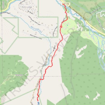
- Distance: 5.2 Km
- Elevation gain: 190 m
- Maximum elevation: 2,394 m
- Elevation loss: 190 m
- Minimum elevation: 2,220 m
- Moving time: 1 h 41 m
- Moving speed: 3.1 Km/h
- Maximum speed: 5.9 Km/h
- Total time: 2 h 44 m
- Global speed: 1.9 Km/h
Interactive trail map
Trail profile
- Distance: 5.2 Km
- Elevation gain: 190 m
- Maximum elevation: 2,394 m
- Elevation loss: 190 m
- Minimum elevation: 2,220 m
- Moving time: 1 h 41 m
- Moving speed: 3.1 Km/h
- Maximum speed: 5.9 Km/h
- Total time: 2 h 44 m
- Global speed: 1.9 Km/h
About this trail
Name: Donut Falls Trail in Uinta-Wasatch-Cache National Forest trail, distance, elevation, map, profile, GPS track
Coordinates: 40.63132 -111.65477 40.64918 -111.64740
Other hiking, mountain biking, running and outdoor activity trails
Click on a trail to view its statistics, map and profile.