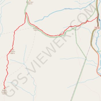
Mount Isolation, North Isolation and Gulf Peak
Hike to Mount Isolation via Glen Boulder Trail, Gulf Peak, Davis Path, North Isolation and Isolation Trail in the White Mountain National Forest, the Pinkham North Scenic Area and the Presidential Range-Dry River Wilderness. #Hiking #Mountain #Nature #Forest #Wilderness
- Distance: 17.4 Km
- Elevation gain: 1,411 m
- Maximum elevation: 1,572 m
- Elevation loss: 1,510 m
- Minimum elevation: 599 m
- Moving time: 6 h 22 m
- Moving speed: 2.7 Km/h
- Maximum speed: 5.3 Km/h
- Total time: 7 h 19 m
- Global speed: 2.4 Km/h
Interactive trail map
Trail profile
- Distance: 17.4 Km
- Elevation gain: 1,411 m
- Maximum elevation: 1,572 m
- Elevation loss: 1,510 m
- Minimum elevation: 599 m
- Moving time: 6 h 22 m
- Moving speed: 2.7 Km/h
- Maximum speed: 5.3 Km/h
- Total time: 7 h 19 m
- Global speed: 2.4 Km/h
About this trail
Name: Mount Isolation, North Isolation and Gulf Peak trail, distance, elevation, map, profile, GPS track
Start: Glen Boulder Trail, Pinkham's Grant, Coös County, New Hampshire, United States (44.24400 -71.25946)
Coordinates: 44.21485 -71.30951 44.24748 -71.25369
Other hiking, mountain biking, running and outdoor activity trails
Click on a trail to view its statistics, map and profile.
Presidential Range Traverse
United States > New Hampshire > Coos County > Bowman
Starting near the northern gateway of the Presidential Range, this traverse climbs from the forests of the White Mountain National Forest to the exposed ridgeline of Mount Madison, then continues over the rugged summits of Mount Adams and Mount Jefferson, with wide views across the Great Gulf and the…
Distance: 32.3 Km • Elevation gain: 2,545 m • Maximum elevation: 1,911 m