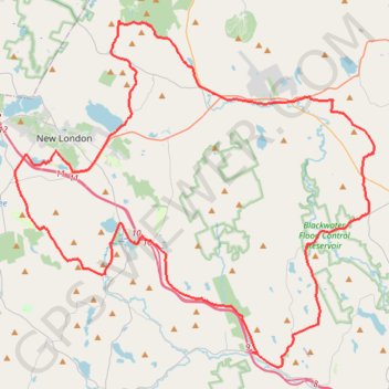
Kearsarge Klassic 55 from Pleasant Lake
Around Mount Kearsarge Klassic route
- Distance: 91.8 Km
- Elevation gain: 1,446 m
- Maximum elevation: 473 m
- Elevation loss: 1,441 m
- Minimum elevation: 128 m
- Moving time: 5 h 35 m
- Moving speed: 16.4 Km/h
- Maximum speed: 58.3 Km/h
- Total time: 6 h 12 m
- Global speed: 14.8 Km/h
Interactive trail map
Trail profile
- Distance: 91.8 Km
- Elevation gain: 1,446 m
- Maximum elevation: 473 m
- Elevation loss: 1,441 m
- Minimum elevation: 128 m
- Moving time: 5 h 35 m
- Moving speed: 16.4 Km/h
- Maximum speed: 58.3 Km/h
- Total time: 6 h 12 m
- Global speed: 14.8 Km/h
About this trail
Name: Kearsarge Klassic 55 from Pleasant Lake trail, distance, elevation, map, profile, GPS track
Coordinates: 43.27983 -72.02455 43.48190 -71.73630
Other hiking, mountain biking, running and outdoor activity trails
Click on a trail to view its statistics, map and profile.
Webb Forest Trail, Wolf Tree, Bunker and Cocoa trails loop
United States > New Hampshire > Merrimack County > New London > Elkins
Distance: 7.9 Km • Elevation gain: 241 m • Maximum elevation: 452 m
Gile State Forest Loop near Morgan Hill
United States > New Hampshire > Merrimack County > New London
Distance: 8.7 Km • Elevation gain: 194 m • Maximum elevation: 550 m
Elkins Loop / New London NH area
United States > New Hampshire > Merrimack County > New London > Elkins
Distance: 26.5 Km • Elevation gain: 373 m • Maximum elevation: 392 m
Lake Sunapee NH area
United States > New Hampshire > Merrimack County > New London > Elkins
Sunday Views NH
Distance: 53.3 Km • Elevation gain: 977 m • Maximum elevation: 458 m