Thank you for supporting this site ❤️
Make a donation
Make a donation
Gear up for your next adventure:
As an Amazon Associate, this site earns from qualifying purchases at no extra cost to you.
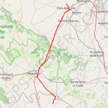
Itinerario 20220127-160459
- Distance: 48.3 Km
- Elevation gain: 324 m
- Maximum elevation: 453 m
- Elevation loss: 541 m
- Minimum elevation: 132 m
Interactive trail map
Thank you for supporting this site ❤️
Make a donation
Make a donation
Gear up for your next adventure:
As an Amazon Associate, this site earns from qualifying purchases at no extra cost to you.
Trail profile
- Distance: 48.3 Km
- Elevation gain: 324 m
- Maximum elevation: 453 m
- Elevation loss: 541 m
- Minimum elevation: 132 m
Thank you for supporting this site ❤️
Make a donation
Make a donation
Gear up for your next adventure:
As an Amazon Associate, this site earns from qualifying purchases at no extra cost to you.
About this trail
Name: Itinerario 20220127-160459 trail, distance, elevation, map, profile, GPS track
Start: Masseria Giura Longo, Matera, Basilicata, Italy (40.72158 16.64042)
Coordinates: 40.72158 16.56636 41.07104 16.72337
Thank you for supporting this site ❤️
Make a donation
Make a donation
Gear up for your next adventure:
As an Amazon Associate, this site earns from qualifying purchases at no extra cost to you.