Lewis & Clark Loop Trail via Lewis Trail in Weldon Spring Conservation Area
The Lewis & Clark Loop Trail via the Lewis Trail offers hikers a moderate, scenic route through a mix of wooded areas, creek beds, and elevated ridges, with remarkable views of the Missouri River and nearby Howell Island. As you follow the trail, you will encounter several overlooks, particularly from the bluff edges, providing sweeping views that are especially stunning in the winter when foliage doesn’t obscure the horizon. The trail features a variety of environments, from quiet creek crossings to gradual inclines, making it an enjoyable but occasionally challenging hike, particularly if the weather has been rainy, which may result in muddy patches or streams that require careful navigation. #Hiking #Loop #River #Forest #Nature
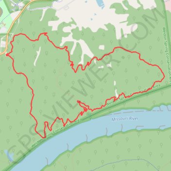
- Distance: 13.5 Km
- Elevation gain: 245 m
- Maximum elevation: 202 m
- Elevation loss: 245 m
- Minimum elevation: 151 m
- Moving time: 2 h 51 m
- Moving speed: 4.7 Km/h
- Maximum speed: 8.7 Km/h
- Total time: 3 h 4 m
- Global speed: 4.4 Km/h
Interactive trail map
Trail profile
- Distance: 13.5 Km
- Elevation gain: 245 m
- Maximum elevation: 202 m
- Elevation loss: 245 m
- Minimum elevation: 151 m
- Moving time: 2 h 51 m
- Moving speed: 4.7 Km/h
- Maximum speed: 8.7 Km/h
- Total time: 3 h 4 m
- Global speed: 4.4 Km/h
About this trail
Name: Lewis & Clark Loop Trail via Lewis Trail in Weldon Spring Conservation Area trail, distance, elevation, map, profile, GPS track
Start: Lewis & Clark Trail, Saint Charles County, Missouri, United States (38.69090 -90.72419)
End: Lewis & Clark Trail, O’Fallon, Saint Charles County, Missouri, United States (38.69100 -90.72444)
Coordinates: 38.67569 -90.72445 38.69498 -90.68723
Other hiking, mountain biking, running and outdoor activity trails
Click on a trail to view its statistics, map and profile.
Lewis & Clark Loop Trail via Clark Trail in Weldon Spring Conservation Area
United States > Missouri > Saint Charles County > O’Fallon
The Lewis & Clark Loop Trail via the Clark Trail offers a scenic hike with a variety of natural landscapes. As you traverse the loop, you'll encounter beautiful bluff views of the Missouri River, particularly as you reach the higher elevations along the trail. The route also passes through diverse…
Distance: 8.5 Km • Elevation gain: 162 m • Maximum elevation: 202 m