Kuwohi Trail to Observation Tower in the Great Smoky Mountains National Park
The hike to the Kuwohi Observation Tower offers stunning panoramic views from the highest point in the park, previously known as Clingmans Dome. As you ascend the paved, yet steep, trail, you'll be rewarded with vistas of expansive mountain ranges, including Sugarland Mountain and the Elkmont area. On clear days, the 360-degree views extend for miles, offering a breathtaking perspective of the surrounding wilderness, making it a popular spot for both sunrise and sunset. #Hiking #Mountain #Overlook #Forest #Nature
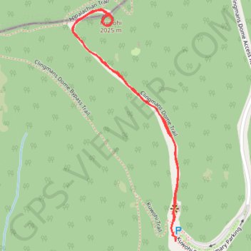
- Distance: 2.1 Km
- Elevation gain: 106 m
- Maximum elevation: 2,021 m
- Elevation loss: 111 m
- Minimum elevation: 1,910 m
- Moving time: 27 m 51 s
- Moving speed: 4.5 Km/h
- Maximum speed: 6.6 Km/h
- Total time: 29 m 42 s
- Global speed: 4.3 Km/h
Interactive trail map
Trail profile
- Distance: 2.1 Km
- Elevation gain: 106 m
- Maximum elevation: 2,021 m
- Elevation loss: 111 m
- Minimum elevation: 1,910 m
- Moving time: 27 m 51 s
- Moving speed: 4.5 Km/h
- Maximum speed: 6.6 Km/h
- Total time: 29 m 42 s
- Global speed: 4.3 Km/h
About this trail
Name: Kuwohi Trail to Observation Tower in the Great Smoky Mountains National Park trail, distance, elevation, map, profile, GPS track
Start: Kuwohi Trail, Swain County, North Carolina, United States (35.55709 -83.49621)
End: Kuwohi Road Primary Parking, Swain County, North Carolina, United States (35.55653 -83.49614)
Coordinates: 35.55653 -83.49971 35.56305 -83.49605
Other hiking, mountain biking, running and outdoor activity trails
Click on a trail to view its statistics, map and profile.
Great Smoky Mountains Appalachian Trail
United States > North Carolina > Clay County
Hike through Great Smoky Mountains along Appalachian Trail via Standing Indian, Ridgepole Mountain, Yellow Bald, Wine Spring Bald, Copper Ridge Bald, Cheoah Bald, Wauchecha Bald, Fontana Dam, Thunderhead Mountain, Clingmans Dome, Mount Kephart and Mount Guyot. #Hiking #Mountain #Nature #Forest #Lake…
Distance: 231.7 Km • Elevation gain: 8,873 m • Maximum elevation: 2,013 m