Thank you for supporting this site ❤️
Make a donation
Make a donation
Gear up for your next adventure:
As an Amazon Associate, this site earns from qualifying purchases at no extra cost to you.
Berrinba Wetlands Nature Refuge
Interactive trail map
Thank you for supporting this site ❤️
Make a donation
Make a donation
Gear up for your next adventure:
As an Amazon Associate, this site earns from qualifying purchases at no extra cost to you.
Trail profile
- Distance: 1.8 Km
- Elevation gain: 9 m
- Maximum elevation: 19 m
- Elevation loss: 10 m
- Minimum elevation: 12 m
- Moving time: 21 m 22 s
- Moving speed: 5.0 Km/h
- Maximum speed: 13.4 Km/h
- Total time: 23 m 1 s
- Global speed: 4.7 Km/h
Thank you for supporting this site ❤️
Make a donation
Make a donation
Gear up for your next adventure:
As an Amazon Associate, this site earns from qualifying purchases at no extra cost to you.
About this trail
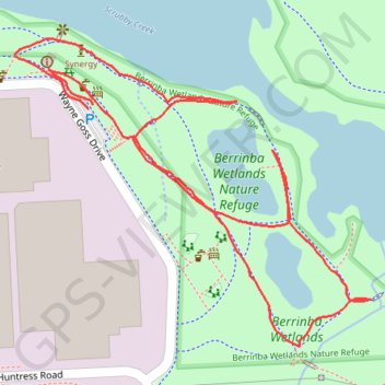
Name: Berrinba Wetlands Nature Refuge trail, distance, elevation, map, profile, GPS track
Start: Wayne Goss Drive, Berrinba, Greater Brisbane, Queensland, 4117, Australia (-27.66652 153.07829)
End: Wayne Goss Drive, Berrinba, Greater Brisbane, Queensland, 4117, Australia (-27.66648 153.07835)
Coordinates: -27.66912 153.07738 -27.66575 153.08178
Thank you for supporting this site ❤️
Make a donation
Make a donation
Gear up for your next adventure:
As an Amazon Associate, this site earns from qualifying purchases at no extra cost to you.