Thank you for supporting this site ❤️
Make a donation
Make a donation
Gear up for your next adventure:
As an Amazon Associate, this site earns from qualifying purchases at no extra cost to you.
Werribee Gorge Circuit Walk
Interactive trail map
Thank you for supporting this site ❤️
Make a donation
Make a donation
Gear up for your next adventure:
As an Amazon Associate, this site earns from qualifying purchases at no extra cost to you.
Trail profile
- Distance: 7.7 Km
- Elevation gain: 307 m
- Maximum elevation: 346 m
- Elevation loss: 307 m
- Minimum elevation: 140 m
- Moving time: 1 h 24 m
- Moving speed: 5.5 Km/h
- Maximum speed: 15.5 Km/h
- Total time: 1 h 28 m
- Global speed: 5.2 Km/h
Thank you for supporting this site ❤️
Make a donation
Make a donation
Gear up for your next adventure:
As an Amazon Associate, this site earns from qualifying purchases at no extra cost to you.
About this trail
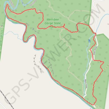
Name: Werribee Gorge Circuit Walk trail, distance, elevation, map, profile, GPS track
Coordinates: -37.67292 144.34568 -37.65629 144.36619
Thank you for supporting this site ❤️
Make a donation
Make a donation
Gear up for your next adventure:
As an Amazon Associate, this site earns from qualifying purchases at no extra cost to you.
Other hiking, mountain biking, running and outdoor activity trails
Click on a trail to view its statistics, map and profile.