Make a donation
Gear up for your next adventure:
As an Amazon Associate, this site earns from qualifying purchases at no extra cost to you.
2014-07-29 06:09:07 Auto
- Distance: 60.8 Km
- Elevation gain: 307 m
- Maximum elevation: 38 m
- Elevation loss: 296 m
- Minimum elevation: -3 m
Interactive trail map
Make a donation
Gear up for your next adventure:
As an Amazon Associate, this site earns from qualifying purchases at no extra cost to you.
Trail profile
- Distance: 60.8 Km
- Elevation gain: 307 m
- Maximum elevation: 38 m
- Elevation loss: 296 m
- Minimum elevation: -3 m
Make a donation
Gear up for your next adventure:
As an Amazon Associate, this site earns from qualifying purchases at no extra cost to you.
About this trail
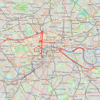
Name: 2014-07-29 06:09:07 Auto trail, distance, elevation, map, profile, GPS track
Coordinates: 51.47770 -0.21194 51.53242 -0.00119
Make a donation
Gear up for your next adventure:
As an Amazon Associate, this site earns from qualifying purchases at no extra cost to you.
Other hiking, mountain biking, running and outdoor activity trails
Click on a trail to view its statistics, map and profile.
Burgess Park
United Kingdom > England > Greater London
Distance: 5.3 Km • Elevation gain: 16 m • Maximum elevation: 6 m
Make a donation
Gear up for your next adventure:
As an Amazon Associate, this site earns from qualifying purchases at no extra cost to you.
Northern Section of Green Link Walk from Epping Forest to Smithfield Market
United Kingdom > England > London
Distance: 17.5 Km • Elevation gain: 71 m • Maximum elevation: 46 m
Green Link Walk from Smithfield Market to end at Pekham
United Kingdom > England > City of London
Distance: 8.7 Km • Elevation gain: 41 m • Maximum elevation: 34 m
London Marathon
United Kingdom > England > London
Distance: 42.2 Km • Elevation gain: 281 m • Maximum elevation: 50 m
Night Run
United Kingdom > England > London
Distance: 11.0 Km • Elevation gain: 73 m • Maximum elevation: 42 m
Make a donation
Gear up for your next adventure:
As an Amazon Associate, this site earns from qualifying purchases at no extra cost to you.