Thank you for supporting this site ❤️
Make a donation
Make a donation
Gear up for your next adventure:
As an Amazon Associate, this site earns from qualifying purchases at no extra cost to you.
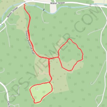
Treanor Preserve Trail
Interactive trail map
Thank you for supporting this site ❤️
Make a donation
Make a donation
Gear up for your next adventure:
As an Amazon Associate, this site earns from qualifying purchases at no extra cost to you.
Trail profile
- Distance: 2.3 Km
- Elevation gain: 62 m
- Maximum elevation: 202 m
- Elevation loss: 63 m
- Minimum elevation: 151 m
- Moving time: 32 m 16 s
- Moving speed: 4.3 Km/h
- Maximum speed: 5.4 Km/h
- Total time: 32 m 16 s
- Global speed: 4.3 Km/h
Thank you for supporting this site ❤️
Make a donation
Make a donation
Gear up for your next adventure:
As an Amazon Associate, this site earns from qualifying purchases at no extra cost to you.
About this trail
Name: Treanor Preserve Trail trail, distance, elevation, map, profile, GPS track
Coordinates: 40.68376 -74.82773 40.68960 -74.82316
Thank you for supporting this site ❤️
Make a donation
Make a donation
Gear up for your next adventure:
As an Amazon Associate, this site earns from qualifying purchases at no extra cost to you.