Thank you for supporting this site ❤️
Make a donation
Make a donation
Gear up for your next adventure:
As an Amazon Associate, this site earns from qualifying purchases at no extra cost to you.
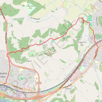
Conwy Trail Running
Bryn
- Distance: 6.4 Km
- Elevation gain: 124 m
- Maximum elevation: 104 m
- Elevation loss: 120 m
- Minimum elevation: 2 m
- Moving time: 48 m 36 s
- Moving speed: 7.9 Km/h
- Maximum speed: 14.4 Km/h
- Total time: 55 m 42 s
- Global speed: 6.9 Km/h
Interactive trail map
Thank you for supporting this site ❤️
Make a donation
Make a donation
Gear up for your next adventure:
As an Amazon Associate, this site earns from qualifying purchases at no extra cost to you.
Trail profile
- Distance: 6.4 Km
- Elevation gain: 124 m
- Maximum elevation: 104 m
- Elevation loss: 120 m
- Minimum elevation: 2 m
- Moving time: 48 m 36 s
- Moving speed: 7.9 Km/h
- Maximum speed: 14.4 Km/h
- Total time: 55 m 42 s
- Global speed: 6.9 Km/h
Thank you for supporting this site ❤️
Make a donation
Make a donation
Gear up for your next adventure:
As an Amazon Associate, this site earns from qualifying purchases at no extra cost to you.
About this trail
Name: Conwy Trail Running trail, distance, elevation, map, profile, GPS track
Start: Conway Road, Llandudno Junction, Conwy, Wales, LL31 9LN, United Kingdom (53.28431 -3.80887)
End: Bryn Marl Road, Mochdre, Conwy, Wales, LL28 5DY, United Kingdom (53.29212 -3.76236)
Coordinates: 53.28431 -3.80887 53.30473 -3.76002
Thank you for supporting this site ❤️
Make a donation
Make a donation
Gear up for your next adventure:
As an Amazon Associate, this site earns from qualifying purchases at no extra cost to you.