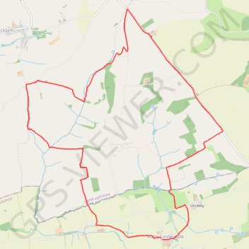
Kirby Underdale loop
East Riding of Yorkshire Trail Running
- Distance: 12.2 Km
- Elevation gain: 286 m
- Maximum elevation: 237 m
- Elevation loss: 285 m
- Minimum elevation: 70 m
- Moving time: 1 h 41 m
- Moving speed: 7.2 Km/h
- Maximum speed: 13.4 Km/h
- Total time: 1 h 48 m
- Global speed: 6.7 Km/h
Interactive trail map
Trail profile
- Distance: 12.2 Km
- Elevation gain: 286 m
- Maximum elevation: 237 m
- Elevation loss: 285 m
- Minimum elevation: 70 m
- Moving time: 1 h 41 m
- Moving speed: 7.2 Km/h
- Maximum speed: 13.4 Km/h
- Total time: 1 h 48 m
- Global speed: 6.7 Km/h
About this trail
Name: Kirby Underdale loop trail, distance, elevation, map, profile, GPS track
Coordinates: 54.01678 -0.80209 54.04803 -0.75667
Other hiking, mountain biking, running and outdoor activity trails
Click on a trail to view its statistics, map and profile.
Hike from Pocklington to Fridaythorpe
United Kingdom > England > East Riding of Yorkshire > York
Distance: 17.5 Km • Elevation gain: 471 m • Maximum elevation: 206 m
East Riding of Yorkshire Trail Running
United Kingdom > England > East Riding of Yorkshire
Distance: 33.5 Km • Elevation gain: 505 m • Maximum elevation: 235 m
Acklam loop
United Kingdom > England > North Yorkshire > Norton-on-Derwent
Distance: 34.8 Km • Elevation gain: 551 m • Maximum elevation: 237 m