Thank you for supporting this site ❤️
Make a donation
Make a donation
Gear up for your next adventure:
As an Amazon Associate, this site earns from qualifying purchases at no extra cost to you.
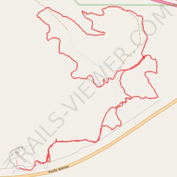
East Loop Trail
- Distance: 5.2 Km
- Elevation gain: 146 m
- Maximum elevation: 777 m
- Elevation loss: 147 m
- Minimum elevation: 701 m
- Moving time: 1 h 8 m
- Moving speed: 4.5 Km/h
- Maximum speed: 10.8 Km/h
- Total time: 1 h 11 m
- Global speed: 4.4 Km/h
Interactive trail map
Thank you for supporting this site ❤️
Make a donation
Make a donation
Gear up for your next adventure:
As an Amazon Associate, this site earns from qualifying purchases at no extra cost to you.
Trail profile
- Distance: 5.2 Km
- Elevation gain: 146 m
- Maximum elevation: 777 m
- Elevation loss: 147 m
- Minimum elevation: 701 m
- Moving time: 1 h 8 m
- Moving speed: 4.5 Km/h
- Maximum speed: 10.8 Km/h
- Total time: 1 h 11 m
- Global speed: 4.4 Km/h
Thank you for supporting this site ❤️
Make a donation
Make a donation
Gear up for your next adventure:
As an Amazon Associate, this site earns from qualifying purchases at no extra cost to you.
About this trail
Name: East Loop Trail trail, distance, elevation, map, profile, GPS track
Start: Pacific Avenue, Medora, Billings County, North Dakota, 58645, United States (46.91052 -103.51369)
Coordinates: 46.91041 -103.51369 46.91821 -103.50402
Thank you for supporting this site ❤️
Make a donation
Make a donation
Gear up for your next adventure:
As an Amazon Associate, this site earns from qualifying purchases at no extra cost to you.