Carlisle Walk
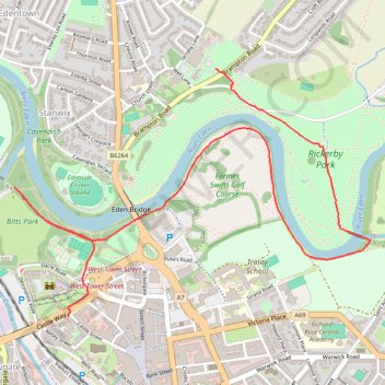
Walk through Carlisle from Carlisle Castle to University of Cumbria via Weaver's Bank, Mayor's Drive, Bitts Park, Swifts Bank, River Eden, Former Swifts Golf Course and Rickerby Park. #Walking #Hiking #Nature #Park #Forest #River #Castle
- Distance: 4.2 Km
- Elevation gain: 23 m
- Maximum elevation: 28 m
- Elevation loss: 18 m
- Minimum elevation: 12 m
- Moving time: 59 m 48 s
- Moving speed: 4.3 Km/h
- Maximum speed: 12.3 Km/h
- Total time: 1 h 1 m
- Global speed: 4.1 Km/h
Interactive trail map
Trail profile
- Distance: 4.2 Km
- Elevation gain: 23 m
- Maximum elevation: 28 m
- Elevation loss: 18 m
- Minimum elevation: 12 m
- Moving time: 59 m 48 s
- Moving speed: 4.3 Km/h
- Maximum speed: 12.3 Km/h
- Total time: 1 h 1 m
- Global speed: 4.1 Km/h
About this trail
Name: Carlisle Walk trail, distance, elevation, map, profile, GPS track
Coordinates: 54.89599 -2.94422 54.90579 -2.91977
Other hiking, mountain biking, running and outdoor activity trails
Click on a trail to view its statistics, map and profile.
Carlisle Running
United Kingdom > England > Cumberland > Carlisle
Rat race the wall 2024
Distance: 112.3 Km • Elevation gain: 1,342 m • Maximum elevation: 332 m