Túnel de les dos valires
- Distance: 105.0 Km
- Elevation gain: 10,829 m
- Maximum elevation: 1,736 m
- Elevation loss: 10,829 m
- Minimum elevation: 1,024 m
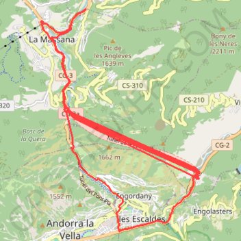
Interactive trail map
Trail profile
- Distance: 105.0 Km
- Elevation gain: 10,829 m
- Maximum elevation: 1,736 m
- Elevation loss: 10,829 m
- Minimum elevation: 1,024 m
About this trail
Name: Túnel de les dos valires trail, distance, elevation, map, profile, GPS track
Start: Avinguda del Pont d'Ordino, Ordino, AD300, Andorra (42.55011 1.52558)
End: Avinguda del Pont d'Ordino, Ordino, AD300, Andorra (42.55006 1.52548)
Coordinates: 42.50640 1.51347 42.55011 1.55579
Other hiking, mountain biking, running and outdoor activity trails
Click on a trail to view its statistics, map and profile.
Southern section — European Divide Trail
France > Auvergne-Rhône-Alpes > Drôme > Valence
Distance: 2,423.8 Km • Elevation gain: 42,375 m • Maximum elevation: 2,005 m
GR 10 - Traversée des Pyrénées
France > Occitania > Pyrénées-Orientales > Banyuls-sur-Mer
Distance: 874.8 Km • Elevation gain: 57,000 m • Maximum elevation: 2,599 m
1 LUCENA - MONTPELLIER
Distance: 2,964.4 Km • Elevation gain: 29,500 m • Maximum elevation: 1,048 m