Thank you for supporting this site ❤️
Make a donation
Make a donation
Gear up for your next adventure:
As an Amazon Associate, this site earns from qualifying purchases at no extra cost to you.
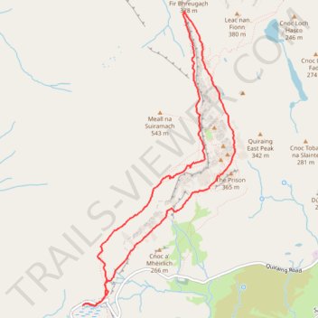
Quiraing Loop
- Distance: 7.0 Km
- Elevation gain: 375 m
- Maximum elevation: 523 m
- Elevation loss: 376 m
- Minimum elevation: 254 m
- Moving time: 2 h 4 m
- Moving speed: 3.4 Km/h
- Maximum speed: 6.5 Km/h
- Total time: 2 h 17 m
- Global speed: 3.0 Km/h
Interactive trail map
Thank you for supporting this site ❤️
Make a donation
Make a donation
Gear up for your next adventure:
As an Amazon Associate, this site earns from qualifying purchases at no extra cost to you.
Trail profile
- Distance: 7.0 Km
- Elevation gain: 375 m
- Maximum elevation: 523 m
- Elevation loss: 376 m
- Minimum elevation: 254 m
- Moving time: 2 h 4 m
- Moving speed: 3.4 Km/h
- Maximum speed: 6.5 Km/h
- Total time: 2 h 17 m
- Global speed: 3.0 Km/h
Thank you for supporting this site ❤️
Make a donation
Make a donation
Gear up for your next adventure:
As an Amazon Associate, this site earns from qualifying purchases at no extra cost to you.
About this trail
Name: Quiraing Loop trail, distance, elevation, map, profile, GPS track
Coordinates: 57.62810 -6.29257 57.65073 -6.27067
Thank you for supporting this site ❤️
Make a donation
Make a donation
Gear up for your next adventure:
As an Amazon Associate, this site earns from qualifying purchases at no extra cost to you.
Other hiking, mountain biking, running and outdoor activity trails
Click on a trail to view its statistics, map and profile.
Quiraing
United Kingdom > Scotland > Highland
The Prison - The Needle - The Table - Fir Bhreugach - Leac na' Fionn - Sròn Vourlinn Isle of Skye
Distance: 9.5 Km • Elevation gain: 409 m • Maximum elevation: 348 m