Thank you for supporting this site ❤️
Make a donation
Make a donation
Gear up for your next adventure:
As an Amazon Associate, this site earns from qualifying purchases at no extra cost to you.
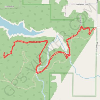
River to River Trail - Shawnee National Forest
Jackson County Walking
- Distance: 8.2 Km
- Elevation gain: 169 m
- Maximum elevation: 211 m
- Elevation loss: 166 m
- Minimum elevation: 141 m
- Moving time: 1 h 56 m
- Moving speed: 4.2 Km/h
- Maximum speed: 15.9 Km/h
- Total time: 1 h 58 m
- Global speed: 4.2 Km/h
Interactive trail map
Thank you for supporting this site ❤️
Make a donation
Make a donation
Gear up for your next adventure:
As an Amazon Associate, this site earns from qualifying purchases at no extra cost to you.
Trail profile
- Distance: 8.2 Km
- Elevation gain: 169 m
- Maximum elevation: 211 m
- Elevation loss: 166 m
- Minimum elevation: 141 m
- Moving time: 1 h 56 m
- Moving speed: 4.2 Km/h
- Maximum speed: 15.9 Km/h
- Total time: 1 h 58 m
- Global speed: 4.2 Km/h
Thank you for supporting this site ❤️
Make a donation
Make a donation
Gear up for your next adventure:
As an Amazon Associate, this site earns from qualifying purchases at no extra cost to you.
About this trail
Name: River to River Trail - Shawnee National Forest trail, distance, elevation, map, profile, GPS track
Start: New River to River Trail, Makanda, Jackson County, Illinois, United States (37.61319 -89.24822)
End: River to River Trail, Jackson County, Illinois, United States (37.61341 -89.24794)
Coordinates: 37.60606 -89.26674 37.61365 -89.24794
Thank you for supporting this site ❤️
Make a donation
Make a donation
Gear up for your next adventure:
As an Amazon Associate, this site earns from qualifying purchases at no extra cost to you.